This walk takes you from the large village of Ollerton, through the woodland of Boughton Brake and then returning to Ollerton alongside a relatively new track by the River Maun. There is a short diversion if you wish to Old Ollerton. The walk is along roads in Ollerton and then good tracks which should be fine in all underfoot conditions.
Start: I am starting my route from the centre of Ollerton which has pretty good public transport links to most parts of the county. There are plenty of side roads for parking too. You can also start in old Ollerton village or at Boughton Brake where there is space for parking.
Distance: 4.7 miles
Ollerton is a busy village with good amenities many of which lie on or just off the main road through the village (the A6075). I am choosing to start the walk in the centre of the village on this main road at the junction with Briar Road which goes to the main church in Ollerton a little to the north of the A6075. From the junction walk towards St.Paulinus church which is in the centre of an island surrounded by a road acting as a hub with others coming off it. These mostly aren’t busy and have bus stops at different points for the various places served. You should be aiming to leave the area directly straight on so follow the pavement round the circle with the church in the middle and leave the circle on the far side along Lime Tree Road. This goes down quite steeply for a short distance and at the bottom of the hill follow Walesby Lane right for 500m. At the first main junction you come to cross the road ahead (Whinney Lane) and turn left but soon bear right along the pavement to cut the corner instead of walking on the grass next to Whinney Lane. Cross a side road (Hallam Lane) and continue along the surfaced path near the road. There is a wood ahead on your left and houses to the right at first but you soon reach the edge of the village.
Follow the lane as it leaves the village and approaches the woods. You go past a large brick building with a tall chimney, Boughton pumping station, on the left. A little after this the road you have been following turns sharply to the right. At this point you should go left into the woodland area. This is Boughton Brake. Go almost straight on along a well-defined path but bearing slightly left, ignoring the wide track going directly left, and aim for a large wooden post a little way ahead. This part of the Brake is a more open area with fewer trees but as you carry on past the wooden signpost in the same direction on the left hand track the tree cover is greater. You head towards the centre of the wood climbing gently for just over 300m.

Boughton Brake
At the top of the hill the path bends slightly to the left and you start to descend on a wider track. This is a very pleasant path with trees on either side of the path and all around you although slightly further from the path itself so it doesn’t feel oppressive. Continue along this path downhill for 600m until you reach the far corner of the wood which is also a road junction of quiet lanes. Go very slightly on from the corner of the wood and the road turns sharply left. You should turn left here along the road, staying on the right hand side as there is no pavement. After 100m you see a footpath sign on the left of the road and you should leave the road to follow this firm path. It stays almost alongside the road for another 200m when you reach a substantial footbridge where you cross the river Maun. This, and the road bridge just to the north, is known as Whitewater Bridge.

Whitewater Bridge
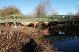
…and footbridge
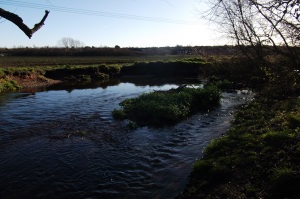
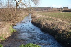
On the other side of the footbridge turn left and go back towards the river along a good track then by the river turn right . Follow this track for the next mile and a half. The river is always just a little to your left and at times you wouldn’t know it was there as it is out of sight, especially in the first half mile. The track is a relatively new one which doesn’t appear on older Ordnance Survey maps. To your right are fields of pigs for much of the way. The path is almost straight and flat the whole way with a few small areas of trees and you can’t go wrong. The river when you meet it again is slow-flowing and gentle. You can go down to it at one point in a pleasant clump of trees.
River Maun
The Maun looking towards Boughton Pumping Station
Eventually you see the houses of Ollerton appearing on the left and the track turns to cross the Maun again over a small but solid wooden plank bridge. The track then bends to the right near houses on your left with a fishing lake appearing on your right. The track gets wider to become a rough road which you follow straight ahead past the entrance to the lakes.
Carry on to the end of the rough road and straight on up a short path which meets the busy A6075 where you turn left. To return to the starting point of the walk you can go along for a short distance and take the first road to the left which takes you up to the main road into New Ollerton. At this point, however, you are close to the old part of Ollerton and you may wish to take a short detour into Old Ollerton where from March to November you can visit the watermill on the Maun, the only active watermill in the county, and award winning tea room next door. To do this go across the A6075 using the crossing and take the first turning off to the right along the Main Street into Old Ollerton. You soon pass an Italian restaurant and see the river Maun to the right near the car park. You can get down to the Maun here opposite a small island with the village war memorial. Ahead at the end of the street is the watermill and tea room just past an information board telling you about the village.
To complete the walk retrace your steps out of Old Ollerton, cross the A6075 at the crossing, then turn right along the pavement. Take the first turning left and follow this road all the way into New Ollerton for half a mile until you reach the centre and your starting point.
