This stage plots a course through the western suburbs of Nottingham that wanders around a little but manages to link together some nice areas of urban greenery. Then it goes via the old Nottingham Canal across fields to Strelley and Kimberley.
There are frequent buses from Wollaton Vale into Nottingham and the 35 bus route also comes close to this stage at a few points should you wish to return to your start point. To return to Nottingham from Kimberley you can catch Rainbow One buses from Trent Barton every ten minutes.
Start: Wollaton Vale (the main road just to the west of Wollaton Park) (continuing from Stage 1)
Finish: The centre of Kimberley on Nottingham Road (continues to Stage 3)
Distance: 12.2km (7.6 miles)
Description of the Route
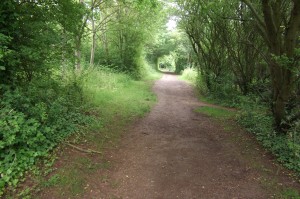
Cross Parkside and descend the short street opposite (Wollaton Rise) to reach a junction with a main road (Wollaton Vale). Go left for a few metres then cross Wollaton Vale and enter the road opposite (Woodbank Drive) which you go along for 100m. Take the first left (Vines Cross) and continue to the junction with Appledore Avenue where you turn left. Follow this as it curves right and at the end of the curve turn right into a cul-de-sac (Kingsdown Mount). At the top of the rise turn left to the end of the cul-de-sac and then between numbers 30 and 32 on the right take a track uphill which soon becomes earthy as you go under trees and into Bramcote Hills.
Keep straight on up the hill ignoring a right and left turn. At a path junction near the top of the hill turn right along a clear track following the Robin Hood Way marker for about 250m with trees on either side. You reach a playground and turn left for a short distance until you reach Markham Road. Go straight on along the road for 100m to a junction where you turn right and go along Sandy Lane to the end of a cul-de-sac and then onto a bridleway going under trees ahead.
Follow this until you come into a more open area where the more obvious track continues ahead but you should take a path going uphill to the left. This takes you to a wide road (Thoresby Road) which you go straight across and along a footpath between fences. You soon reach a quieter road (Deddington Lane) and turn left along the pavement without crossing. The road bears right to become Eastcote Avenue but you should keep straight on along a tree-lined track with rough parkland of a former golf course to the left.

After 700m at a junction with a wider track turn left uphill. Very soon you reach another path junction and turn right. You can follow the main track here but it is possible to take a short cut by going through a small gate to the left and onto a grassy area with a path going uphill across it. Follow the path with views opening up as you climb. At the other side of the grassy area you reach another firm proper track and turn left uphill to reach a wood. Take a diagonal path to the right going uphill. Bear right again after 70m to follow a fence and ignore all left turns. Descend steeply with the fence to your right and reach steps which you go down and then go out to a main road (Coventry Lane, the B6004) which you cross and then turn left along the pavement for 150m.t
On the right you can see a grassy area going up to an unusual rock formation known as the Hemlock Stone which you should go to look at. Then take a path near the wood behind the stone and go into the wood. Take the left fork climbing uphill and another left fork going past a BMX track up to a trig point in a slightly open area.

From the trig point carry on and descend steeply following a path that bears to the right. At the bottom of the wood turn left and then almost immediately right at the edge of more trees. After 50m as you approach a railway turn left through the trees to reach a wide track. Follow this for 250m with a well maintained open grassy area on the left. Turn right where there are a set of signs at a path junction. Follow the Erewash Valley Trail over a railway and onto a path by a disused canal where you turn left.
Before long you approach the perimeter fence of a garden centre which you follow as it turns left and right. Cross the entrance road to the garden centre to reach a path where you see a sign and map of the Erewash Trail. Go straight on along the path which soon goes downhill and bears right into trees. Go over the old canal packhorse bridge (the Swansea Bridge) which overlooks the rather overgrown Nottingham Canal.

Once across the bridge turn immediately left along a narrow path which runs alongside the canal with a field rising to your right. The overgrown canal appears constantly just to your left as you walk under trees. After 500m go over a stile to your right into a field. Ascend gradually away from the canal with a fence on your left. After about 400m you reach a track and turn left for a short distance until meeting the busy A609 (Nottingham Road). Cross this and turn right along the pavement for 300m where you turn left along Waterloo Lane.
It’s nice to be on this much quieter lane which you follow as it leaves the houses behind. A little way away you can see the M1 and hear the roar of traffic. The lane soon descends and bends to the right. There is no pavement but on the right the grass verge is wide and good to walk on.
Where the lane bends to the left look for a footpath sign on the right of the lane. Go through a gap in the trees by the sign into a field. Turn left and follow the edge of the field for 100m. Almost imperceptibly the path turns a little to the right and you find yourself on a wide, straight track. Follow this as you climb steadily towards a spinney, Shaw’s Plantation, at the top of the hill.
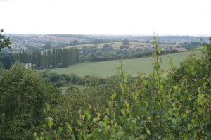
After 500m cross a wide track that is a bridleway between Cossall and Balloon Woods. In another 200m go through a gate and reach the Plantation, where the views are good. In particular you should look to the right where you can clearly see Wollaton Hall and across Nottingham. Carry on along the track past the spinney on your left and then a series of fields on your right.

After 600m you reach a junction with another track and hedge. Turn left along the track to go under beech trees. After 250m the track bends right to meet a road. Turn left along the road and cross it to reach a pavement which is rather unusual as it is half made up of smooth surface and half by uneven paving stones. These can be a little awkward to walk on. It is believed that they were laid by monks many centuries ago on their route between monasteries. Go past Strelley church and soon after that come to Strelley Hall on the right. The Hall has a cafe, gallery and a few speciality businesses and makes a nice stopping off point.

If you aren’t visiting the Hall continue along the road which goes straight on just slightly bending right. As you pass a farm on the left (Home Farm) the road becomes a track. All this time you have been coming closer to the M1 and at the end of the track turn sharp left and cross the motorway on a wide bridge. On the opposite side the temptation is to follow the wide farm track which bends right but instead you should turn left on another track which goes downhill. After 100m the path turns right alongside a hedge and in the distance ahead you see a water tower.
This tower is your guide for the next part of the walk and you head straight towards it along paths and tracks next to fields. After 500m the track becomes a road and where the road bears right you stay straight on along a narrow path. The path soon goes left and right with the water tower close by. Follow the path as it goes alongside a fence by a field and football field on the left with houses on your right. It turns right and left eventually emerging into an arable field. Turn right downhill along a path by the field edge.

At the bottom of the hill you reach a road where you turn right. Amost immediately turn left along Little Lane until reaching a main road. Cross this and turn right to go slightly uphill. Very soon turn down a pathway on the left with a No Cycling sign on it. Follow this surfaced path for a short distance until it comes out on a street (Clive Crescent). Go left for a few metres and take the road going straight on there. This soon reaches another road (Knowle Lane) where you turn left. Go past a small playground on your right to reach a high bridge above the Kimberley bypass.
Cross the bridge from where you can see Nottingham to your right. Once across descend the hill on a road (Knowle Hill). Just before reaching the main road at the bottom turn left onto a narrow path between hedges, with gardens and houses to either side. After 75m turn right down another track coming off the one you are on until reaching the main road (Nottingham Road Kimberley).
The Robin Hood Way continues by going straight across Nottingham Road here and onto the path opposite. That Stage of the Way is described in my post for the Robin Hood Way to Bestwood Village.
However, Kimberley is a convenient place to stop as there are shops and pubs just down the road to the left. There are bus stops very close by on the Nottingham Road if you want to go into Nottingham.


